
Yellowstone paleoecology
This page provides some more detail on what happened in the Yellowstone region at the end of the last Ice Age (the Pleistocene) and, in broad terms, what happened with changes in vegetation during the following 15,000 years of the Holocene--our current warm interval. My particular interest here is in covering what happened with the vegetation. I cover some of what might have happened with animal populations as well, but refer you to other sections for more details on broad-scale changes in hebivore abundance, most notably Pleistocene-Holocene diets and The bison factor.

Insofar as the Pleistocene is concerned, probably the most noteworthy feature of the Yellowstone region was its' extensive ice-cap, prehaps the largest single mass of ice south of the continental ice sheets covering higher latitudes of the continent. The map above left (based on a compilation by Ken Pierce) places the Yellowstone ice cap at its approximate maximum size in context of all the mountain ice caps that have been documented in western North America south of the main ice. You can see the ice cap covering the Wind River Mountains immediately to the south. The map to the right, again thanks to Ken Pierce and his collaborator, Joseph Licciardi, provides more detail on the configuration, size, depth, and dates of maximum extent for the Yellowstone ice cap. The orange dots are associated with dates (in thousand of years before present, or 'ka') for the farthest terminus of various outlet glaciers of the ice cap. For example, the outlet glacier extending down the Yellowstone River through Paradise Valley to the north reached its maximum extent roughly 16,500 years ago. The most recent maximum occurred in the Jackson Hole area roughly 14,600 years ago. The blue lines on the ice cap itself are lines of equal depth for the accumulated ice; the numbers are depth in hundreds of meters. In other words, the deepest part of the ice cap was in excess of 1,100 m (or 3,600 ft) deep. Which is pretty deep.
No doubt this ice cap and the one to the south centered on the Wind River Range created its own weather, probably including fierce katabatic winds that swept down the various valleys. Such weather effects would have made any place downslope nearby the ice sheet an inhospitable place. It is of additional relevance to thinking about habitability to consider broadscale differences in environments between the north and south sides of the Yellowstone ice cap. Most of the information I've been able to find paints a picture of relatively treeless tundra to the north and parklands or woodlands to the south. You can find a continent-sized map of reconstructed climate and vegetation types on the page devoted to bear diets during the Pleistocene-Holocene transition. It is also noteworthy that remains of larger herbivores from the Pleistocene to the north and northeast of the Yellowstone ice cap are rare, whereas, once you get south of the major divides, these remains become quite common.
All of this adds up to a world that would have extremely inhospitable to grizzlies anywhere near the ice cap itself. To the south, conditions would have been much more productive but, as I point out in Early prehistory, there were also probably a number of larger carnivores such as lions and giant short-faced bears that would have been formidable competitors of--if not predators on--grizzly bears. To the north, these large predators seem to have been rare, so it is conceivable that, even though the environment was much less productive, it would have posed fewer hazards. All of this adds up in my mind to a probable scenario where grizzlies existed at low densities in all directions out from the Yellowstone ice cap, for reasons of competition and predation to the south, and for reasons of productivity to the north.
Changes in vegetation

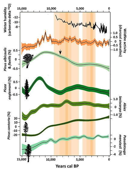
As the Yellowstone ice-cap melted, a process of revegetation commenced in the newly ice-free environments. The process of ice-melt was not uniform. Early-on there were periods of stagnation and local resurgence that had implications for the process of recolonization by various life-forms (see my comments immediately below in reference to cutthroat trout). The figures above synopsize many of the significant vegetation changes that occurred in the Yellowstone region during the last 15,000 years. Essentially all of what I show is the result of the sustained labors of Kathy Whitlock and her many students during the last 25 years. The figure upper right is extracted directly from a recent publication by Kathy and her student Virginia Iglesias. The figure to the left is my contribution. It is based almost wholly (although not totally) on Kathy's work, but represents a unique pictoral synthesis of vegetation changes broken out by different elevational and geomorphic zones, coupled with a representation of temperatures in the northern hemisphere reconstructed from analysis of ancient air extracted from ice cores in the Greenland icecap. I show major periods of Holocene heat and drought by vertical bands of orange, with periods of greater consensus denoted by darker shades. In the figure to the left I also show the progression of different vegetation types over time, with times of major transition noted and dated. I furthermore tried to synoptically illustrate the structure and composition of each vegetation type with diagnostic silhouettes. The composition of the various types is denoted by acronyms: PIAL for whitebark pine (Pinus albicaulis); PIEN for engelmann spruce (Picea engelmannii); ABLA for subalpine fir (Abies lasiocarpa); PICO for lodgepole pine (Pinus contorta); and PSME for Douglas-fir (Pseudotsuga menziesii). Of these, whitebark pine is the most important to grizzly bears because it is--and likely was--a major source of high-quality food in the form of its' fat-rich seeds.
The major patterns? Everywhere except the Central Plateaus of Yellowstone spruce and/or whitebark pine parklands had established by 12,700 to 13,900 years ago. Tundra-lie conditions seem to have persisted on the Central Plateaus for a remarkably long period of time, until roughly 11,800 year ago. Insofar as the initial composition of forests is concerned, spruce and whitebark pine both seem to have the best ability of all conifers to disperse long distances, spruce with the aid of wind, and whitebark pine with the aid of Clark's nutcrackers. These parklands of cold-tolerant species seem to have been sustained for a while by the cold regression of the Younger Dryas (see Early prehistory). However lodgepole pine was able to catch up with these two colonizers within 600 to 900 years. By the peak of Holocene warmth and drought (during the Altithermal, roughly 5,700 to 9,500 years ago) lodgepole pine had become especially widespread, even dominant in most areas. The trend lines to the right reflect these changes. Whitebark pine and Engelmann spruce peaked in relative abundance prior to the Altithermal. The two most warmth and drought-tolerant species--lodgepole pine and Douglas-fir--have progressively increased in abundance throughout the Holocene, along with a decline in winter humidity (snowfall?) and a sustained plateau of wildfire activity.
The implications for grizzly bears? Most of these hinge on the abundance of whitebark pine and the extent of relatively open habitats (see Evolutionary biogeography, Morphology, and Life strategy), perhaps also on the abundance of different species of herbivores (see immediately below). Favorable conditions clearly peaked around 13,000 to 10,000 years ago. After that, forest closed in, climate dried, and whitebark pine proportionately declined. Did grizzly populations follow a similar trajectory? I wouldn't bet on any particular scenario given the complexity of it all.
Changes in animal foods


The map to the left and the figure to the right above pertain to the Holocene history of animals that have probably always been a source of food for grizzly bears in the Yellowstone region: cutthroat trout and larger-bodied hooved herbivores (i.e., ungulates).
Focusing first on cutthroat trout, the map above relates to a basic question that I've always had about this species: How and when did it get into Yellowstone Lake where, at least in recent history, it has been a major source of energy and protein for grizzlies in the central part of the Yellowstone ecosystem? The question arises for me because trout obviously did not survive anywhere in the Yellowstone uplands when this region was covered by an ice cap, and the current outlet of Yellowstone Lake--the Yellowstone River--is blocked to upstream fish migrations by the falls of the Grand Canyon of the Yellowstone. So how did trout get into the Lake? The map above (thanks to Gerry Richmond, a pioneering geologist) shows lacustral and ice contact deposits that accumulated around Yellowstone Lake during the melt of the ice cap. These deposits clearly show that lake levels were much higher during this transition, no doubt because stagnant ice periodically dammed lake outlets. As a result, lake outflows sometimes occurred to the south and west, into the Snake and Firehole Rivers (indicated by the direction of the arrows), rather than to the north down the Yellowstone. Cutthroat trout probably reached the Lake via these south-flowing outlets around 14,000 years ago, which is consistent with the fact that Yellowstone's cutthroat trout are genetically most closely related to trout that reside in the Snake River drainage.
Insofar as ungulates are concerned: We don't have very good evidence for how populations of different species varied during the Holocene in the core of the Yellowstone region. However, thanks to researchers such as George Frison, we have a good sense of these dynamics for the peripheral mountains and surrounding lowlands. Two sources (among several) that I drew on heavily for this information were "Prehistoric Hunter-Gatherers of the High Plains and Rockies" and "Paleoindian Lifeways of the Cody Complex" which summarize the results of numerous paleontological investigations in Montana and Wyoming. I've summarized these results in the graph above right, differentiated by ungulate species. The top panel shows the number of sites where (from left to right) bison, pronghorn, mule deer, bighorn sheep, and elk were found. The bottom panel shows, where given, the number of individual animals of each species (called MNI) documented at each site. These respective counts are ordered for each species from left to right according to time before present, with the oldest sites farthest left, beginning with the late Pleistocene.
Two patterns stand out. First, bison are the most common and elk the least common remains found by paleontologists. Second, the commonness and abundance of remains of all five species have tended to increase over time, especially in the cases of bison and pronghorn. Both of these results could be written off as an artifact of sampling bias. It could be that larger-bodied ungulates or those killed by humans during mass drives are more likely to be documented. The same could hold true for the effect of site age. Younger sites may be more readily detected compared to older sites. However, if the first bias held, elk should be second in abundance to bison, and as likely to be killed during mass drives given their gregarious behavior. Size certainly wouldn't explain differences among pronghorn, deer, and sheep, although deer may have been more likely killed by people as singletons given their solitary tendencies during significant portions of the year. Insofar as the recency factor is concerned, all I can do is reference authorities such as George Frison and Mark Muniz, who concluded that this potential bias is not much of a factor in explaining post-Pleistocene patterns.
So, again, what does this mean for Yellowstone's grizzly bears? Well, for one, the current importance of elk as a source of meat for grizzlies is probably a fairly recent phenomenon. In contrast, prior to recent extirpations, bison were likely a major source of food, especially at lower elevations (see The bison factor). Bighorn sheep were also apparently much more abundant prior to European incursions, and so could have also been a source of meat for bears, especially in the Wind River and Absaroka Mountains. How much of a source? That might have depended on the extent to which grizzlies scavanged kills made by First Peoples for whom sheep were a major source of food. Finally, odds are good that spawning cutthroat have been a significant food source for grizzlies throughout the Holocene, although there are a couple of caveats. First is that cutthroat trout populations apparently decline during warmer drier periods, when hydrologic regimes are less favorable to their survival. If so, then trout populations would have probably declined substantially during the warm dry conditions of the Altithermal--even at the high elevations of Yellowstone Lake. Second is the anomalous lack of trout remains at the numerous paleontological sites investigated around Yellowstone Lake by Douglas MacDonald and his colleagues. They are still scratching their heads over this. Could it be that trout did not, in fact, occupy Yellowstone Lake up until recently? Or is this anomaly explained by the persihability of trout remains? Either way, it is hard to imagine First Peoples using the lake environments and not simultaneously exploiting cutthroat trout if they were present.
